
Introduction
Have you ever looked at a map of Long Island, NY, and wondered what makes this place unique? Stretching from New York City into the Atlantic Ocean, Long Island is a big, beautiful island packed with towns, beaches, and history. Whether you’re planning a trip, moving here, or just curious, a map of Long Island is your key to understanding it all. In this article, we’ll take a fun, easy journey through what this map shows—where it is, what’s on it, and why it matters. With simple words and clear ideas, we’ll cover everything from the island’s shape to its most incredible spots. So, grab a snack, get comfy, and explore Long Island together!
Where Is Long Island on the Map?
Let’s start with the basics: where is Long Island, NY? If you look at a map of the United States, zoom in on New York State. Down in the southeast corner, you’ll see a long, skinny island sticking out from New York City. That’s Long Island! It’s about 118 miles long from west to east and up to 23 miles wide from north to south. It sits right next to the Atlantic Ocean, with water all around it.
To the west, a map of Long Island shows it touching New York City. Parts of the island, like Brooklyn and Queens, are actually boroughs of the city. To the north, there’s Long Island Sound, a significant stretch of water separating it from Connecticut. To the south and east, it’s all ocean—perfect for beaches! This spot makes Long Island a busy, exciting place close to the big city but with its vibe.
The Shape of Long Island: A Fish with Two Tails
Have you ever noticed how a map of Long Island looks like a fish? It’s got a broad head in the west near New York City and a body that stretches out east. Then, at the end, it splits into two tails! These are called the North Fork and South Fork. The North Fork goes up a bit, and the South Fork dips down, ending at Montauk Point. This fishy shape isn’t just incredible; it tells you a lot about the island.
The split at the end makes two different areas. The South Fork has fancy places like the Hamptons, while the North Fork is quieter with farms and wineries. A map of Long Island helps you see how these tails make the island unique, with different things to do depending on which fork you pick.
What’s on the Map of Long Island, NY?
A good Long Island, NY map shows more than just water and land. It’s packed with towns, roads, and fun spots. Let’s break it down so you know what you’re looking at when you check one out.
Counties and Big Areas
Long Island has four counties, and a map of Long Island marks them. Starting from the west, you’ve got Kings County (that’s Brooklyn) and Queens County (Queens). These are part of New York City, so they’re busy with many people. Then, moving east, there’s Nassau County and Suffolk County. These two cover the rest of the island and feel less like the city, with more suburbs and open space.
Nassau is closer to the city and has towns like Hempstead and Long Beach. Suffolk is bigger and stretches to the forks, with places like Huntington and East Hampton. A map of Long Island splits these counties so you can see how the island changes as you go east.
Towns and Cities
Zoom into a map of Long Island, and you’ll spot tons of towns and cities. There are over 100 of them! In the west, Brooklyn and Queens have neighbourhoods like Coney Island and Flushing. You’ve got places like Glen Cove and Oyster Bay in Nassau. Suffolk has big towns like Islip and Riverhead, plus more minor spots like Shelter Island.
Each town has its own feel. A map of Long Island helps you find them and determine what’s nearby—whether it’s a beach, a park, or a cool downtown area with shops.
Roads and How to Get Around
Getting around Long Island is easy if you’ve got a map of Long Island, NY. The Long Island Expressway (the LIE or I-495) is the east-west main road. It’s like the island’s backbone, connecting the city to the forks. Other big roads, like the Northern State Parkway and Southern State Parkway, help, too.
The Long Island Rail Road (LIRR) is also a super popular train system. A map of Long Island often shows its stations, from Penn Station in the city to Montauk at the end. Ferries cross the Sound to Connecticut—perfect for a day trip!
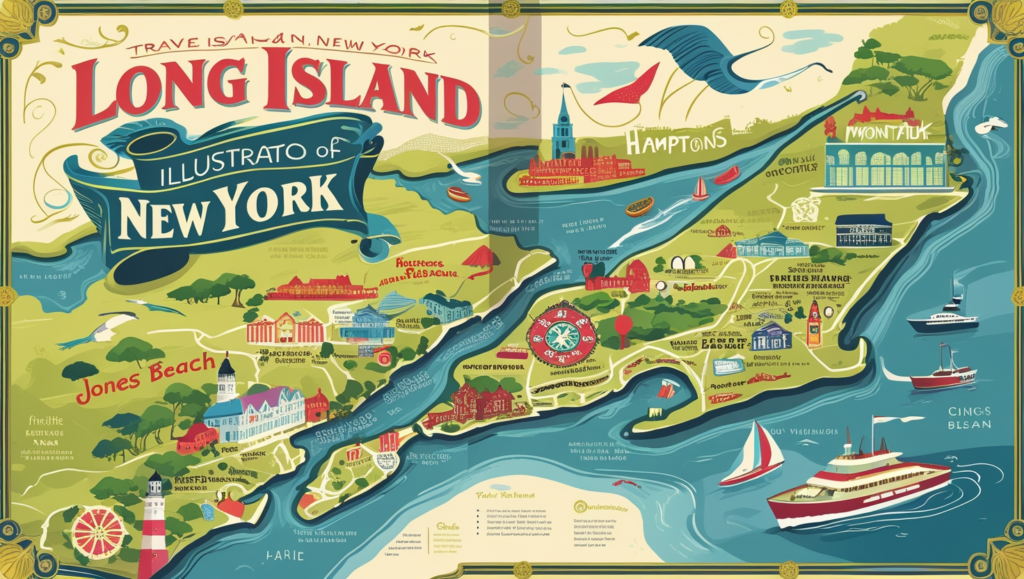
Cool Places You’ll Find on a Map of Long Island
Long Island isn’t just towns and roads—it’s got some fantastic places to visit. A Long Island, NY map points you to the best spots. Let’s check out a few.
Beaches Everywhere
The south shore of Long Island is a beach heaven. A map of Long Island highlights places like Jones Beach, a vast state park with soft sand and waves. Further east, you’ve got Fire Island, a skinny island with no cars—just walk or bike! On the South Fork, the Hamptons have fancy beaches like East Hampton Main Beach.
The north shore has beaches, too, but they’re rockier and face the Sound. Cold Spring Harbor is a pretty spot there. A map of Long Island makes it simple to pick your perfect beach day.
The Hamptons: Fancy and Fun
This area is a big deal. On a map of Long Island, it’s on the South Fork, with towns like Southampton and East Hampton. It’s known for big houses, celebrities, and cute villages with shops. People love it for summer getaways, and the map shows you how to get there from the city.
Montauk: The End of the Island
At the very tip of the South Fork, Montauk is a must-see. A Long Island, NY map marks it as the easternmost point. It’s got a famous lighthouse, great fishing, and a laid-back vibe. Surfers and nature lovers flock here; the map helps you find it easily.
North Fork Wineries
Flip to the North Fork on a map of Long Island, and you’ll see a quieter side. This area is full of farms and wineries. Places like Greenport have tasting rooms where you can sip local wine. It’s less crowded than the Hamptons, and the map shows you the road to explore.
History on the Map of Long Island
Long Island’s story goes way back, and a map of Long Island, NY, can hint at that history. Let’s look at how it started and grew.
Native Americans and Early Days
Before anyone drew a map of Long Island, Native Americans lived here. Tribes like the Lenape were around when Europeans showed up in the 1500s. Explorer Giovanni da Verrazzano sailed in 1524, and Henry Hudson landed in 1609. They didn’t stay, but they literally put Long Island on the map!
English and Dutch Settlers
In the 1600s, English and Dutch people started settling here. A map of Long Island from back then would show towns like Southampton (founded 1640) and Hempstead (1644). The English took over in 1664, and the island became part of New York. Old maps are fun to compare with today’s!
Growing Up in New York
By the 1800s, Long Island was booming. The Long Island RailRoad opened in 1844, making it easy to get to the city. A map of Long Island from that time shows how farms and fishing towns turned into vacation spots for wealthy New Yorkers. Today, it’s a mix of old and new.
Why a Map of Long Island Matters Today
So, why should you care about a map of Long Island, NY, in 2025? It’s more than just lines and names—it’s a tool for life here.
Finding Your Way
With over 8 million people, Long Island is busy! A map of Long Island helps you navigate, whether you’re driving the LIE or catching the LIRR. It shows where towns, beaches, and parks are, so you’re never lost.
Planning a Trip
Visiting Long Island? A map of Long Island, NY, is your best friend. Want to hit Jones Beach, sip wine on the North Fork, or see Montauk’s lighthouse? The map tells you how to get there and what’s nearby. It’s like having a guide in your pocket.
Understanding the Place
Even if you live here, a map of Long Island teaches you about your home. It shows how the island connects to the city, why the forks differ, and where history happened. It’s a simple way to feel closer to this fantastic place.
Facts from the Map of Long Island
Let’s sprinkle in some cool stuff you can spot on a Long Island, NY map.
It’s Huge!
Long Island is the most oversized island in the lower 48 states, with 1,401 square miles. That’s bigger than Rhode Island (the state)! A map of Long Island shows just how much space it covers.
Airports and Travel
The map marks two giant airports—JFK and LaGuardia—in Queens. There’s also Long Island MacArthur Airport in Suffolk. It’s a travel hub, and the map helps you see why.
The Gold Coast
A map of Long Island shows the “Gold Coast ” on the north shore. This area has old mansions from the 1900s, built by super-rich families. Places like Oyster Bay still have that fancy feel.

How to Use a Map of Long Island, NY
Ready to grab a map of Long Island? Here’s how to make it work for you.
Pick the Right One
Many online maps, like Google Maps, or paper ones from a store. A good map of Long Island, NY, clearly shows roads, towns, and fun spots. Look for one with a legend (that little box explaining symbols) to help you read it.
Look Online
Websites like LongIsland.com or MapQuest have interactive maps of Long Island. You can zoom in, click on places, and even get directions. It’s super easy and free!
Keep It Handy
Whether on your phone or folded in your bag, a map of Long Island is a great tool. It’s perfect for spontaneous trips or just learning more about where you are.
The Future of Long Island on the Map
What’s next for Long Island? Today’s map of Long Island, NY, might look different in a few years.
Growing and Changing
The island keeps getting busier, especially near the city. New towns and roads might pop up, and a map of Long Island will show those changes. It’s constantly evolving!
Nature and Fun
People love Long Island for its beaches and parks. Future maps might mark new spots to visit as the island balances growth with keeping its natural beauty.
Tech and Maps
Maps are getting smarter. Soon, a Long Island, NY map might talk to you or show real-time traffic. The basics will remain the same, but how we use them will change.
Why You’ll Love the Map of Long Island
A Long Island, NY map isn’t just paper or pixels—it’s a story. It shows you a place full of life, from city streets to sandy shores. It’s easy to read, fun to explore, and packed with information to improve your day. Whether a visitor or a local, it’s your ticket to understanding this incredible island.
So, what’s your favourite part of Long Island? Have you used a map of Long Island to find something cool? Drop a comment below—I’d love to hear your thoughts! Let’s keep discovering this amazing place together.
References
National Geographic. “Long Island Overview.” www.nationalgeographic.com
New York State Tourism. “Explore Long Island.” www.iloveny.com
Long Island Convention & Visitors Bureau. “Maps and Guides.” www.discoverlongisland.com
U.S. Census Bureau. “Long Island Population Data.” www.census.gov
Britannica. “Long Island, New York.” www.britannica.com

